
07 3396 9988
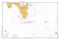
Cape Liptrap to Cliffy Island
SKU:
AUS802 Category:
$0.00
Description:
AUS CHART 802-Cape Liptrap to Cliffy Island
Chart Number Aus802
Title Australia South Coast - Victoria - Cape Liptrap to Cliffy Island
Geog Location Australia
North Lat 38 47.35 S
South Lat 39 33.60 S
East Long 147 19.45 E
West Long 145 45.46 E
Scale 1:150000
Projection mercator
Pub Date 24-Dec-1975
Edition Date 24-Dec-1975
:: Notices to Mariners ::
2012 1196 947
2011 604 363
2010 553
2009 555 375 314 205 74 73
2008 1290 972 705
2007 966
2006 929 579 266 57
2005 765 369 157 65
2004 589 444 72
2003 887 886 844
2002 392 283
2001 457
1999 276
1997 579
1996 662 367 346 345
Additional Info:
The Australian Hydrographic Service currently has over 400 paper charts. All our charts are fully corrected and update to date with the latest Notices to Mariners. The Australian Hydrographic Service was established, and assumed responsibility for hydrographic surveys in Australia, in 1920. In 1946, Cabinet decided that the Royal Australian Navy (RAN) would maintain the national responsibility for hydrographic surveying, nautical charting and the provision of hydrographic services.