
07 3396 9988
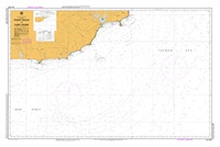
Point Hicks to Cape Howe
SKU:
AUS805 Category:
$0.00
Description:
AUS CHART 805 - Point Hicks to Cape Howe
Chart Number Aus805
Title Australia South Coast - Victoria - Point Hicks to Cape Howe
Geog Location Australia
North Lat 37 28.43 S
South Lat 38 15.50 S
East Long 150 36.67 E
West Long 149 02.75 E
Scale 1:150000
Projection mercator
Pub Date 10-Jun-2005
Edition Date 10-Jun-2005
:: Notices to Mariners ::
2012 293
2009 1232 315 164
2007 967
2006 580 451 249 133
Additional Info:
The Australian Hydrographic Service currently has over 400 paper charts. All our charts are fully corrected and update to date with the latest Notices to Mariners. The Australian Hydrographic Service was established, and assumed responsibility for hydrographic surveys in Australia, in 1920. In 1946, Cabinet decided that the Royal Australian Navy (RAN) would maintain the national responsibility for hydrographic surveying, nautical charting and the provision of hydrographic services.