
07 3396 9988
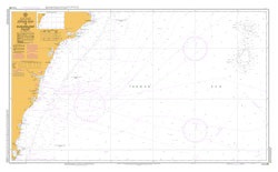
Jervis Bay to Sugarloaf Point
SKU:
AUS489 Category:
$0.00
Description:
AUSTRALIA CHART 489 Jervis Bay to Sugarloaf Point
Chart Number Aus489
Title Australia East Coast - New South Wales - Jervis Bay to Sugarloaf Point
Geog Location Australia
North Lat 32 15.80 S
South Lat 35 12.00 S
East Long 156 40.60 E
West Long 150 40.00 E
Scale 1:500000
Projection mercator
Pub Date 22-May-2009
Edition Date 22-May-2009
Additional Info:
The Australian Hydrographic Service currently has over 400 paper charts. All our charts are fully corrected and update to date with the latest Notices to Mariners. The Australian Hydrographic Service was established, and assumed responsibility for hydrographic surveys in Australia, in 1920. In 1946, Cabinet decided that the Royal Australian Navy (RAN) would maintain the national responsibility for hydrographic surveying, nautical charting and the provision of hydrographic services. RAN is responsible for meeting Australia's obligations to provide hydrographic services as required by the International Convention for the Safety of Life at Sea (SOLAS). Its traditions and methods take their origins from those of the Royal Navy and the pioneers of hydrography. These include names synonymous with Australian history such as; James Cook, Matthew Flinders, William Bligh, Phillip Parker King - all hydrographers; all dedicated to science, exploration and the safety of life at sea